Jul 13, 2009

Why Sierra Negra?

Why go all the way to Sierra Negra in the Galápagos to study shield volcanoes when there are shield volcanoes in Hawaii? That question has several answers. Sierra Negra has unique features that make it an excellent site for comparing and contrasting modes of oceanic island formation. It is a very active volcano, so there should be no shortage of data over the two year collection period. The high activity also makes it ideal for testing new techniques of data integration. Scientists develop models to explain the data they observe and collect. Models lead to discussion, more questions, and development of new ways to test the models. Sierra Negra volcano is an ideal testing ground.

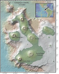
Most oceanic shield volcanoes, like Hawaii and Iceland, form and grow through a process of rifting, dike intrusion and faulting. Their shape is broad and gently rounded, like a warrior’s shield. They form as flow after flow of basaltic lava erupts and spreads over a wide area. A physical inspection and comparison of the islands of Hawaii and Isabela (see Figure 1 and Figure 2) shows some similarities and differences among these oceanic hotspot volcanoes. All of the volcanoes fit the warrior’s shield shape criteria, but there are clear differences in the vent sites where lava erupts. Hawaii has long, linear fissure vents, and the volcanoes of Isabela Island all have large craters. One of the questions we hope to answer is why lava is extruded in a different way on these Galápagos volcanoes? Other questions aren’t as physically obvious and involve the models that fit existing geologic and geophysical data. Seismic and geologic data suggest that the best model for the Hawaiian Islands’ hotspot involves a thickened, bulging mantle overlain by thinned oceanic crust. Data from the Galápagos hotspot fits a contrasting model, one with thickened crust that builds up as magma from the mantle pools and differentiates in the crust before it erupts. These models are known respectively as “underplating” and “overplating.” Using geodesy in combination with seismic reflection data is a new way to test the Galápagos hotspot model. It is also a way to refine the use of space geodesy by developing techniques to image both the shape and movement of the magma chamber that underlies Sierra Negra volcano. This in turn may answer questions about how magma moves through Earth’s crust. When all of the new data from this expedition is integrated to create a 4D model of the internal structure of Sierra Negra volcano, the model for the Galápagos hotspot can be refined.


Figure 1. Hawaii


Figure 2. Isabela


Figure 3. Conceptual ‘overplate’ model of Sierra Negra magmatic plumbing system. Red denotes magmatic dikes(conduits) and sills (reservoirs). The top of the magma system is a mostly liquid sill, whose top is -2 km beneath the caldera floor, but its lateral and vertical dimensions are only loosely constrained (see point 2 ). Beneath this is a thick olivine-gabbro mush, which slowly solidifies as the volcano is carried away from the hotspot.

For more information about shield volcanoes:
http://vulcan.wr.usgs.gov/Glossary/ShieldVolcano/description_shield_volcano.html

http://www.mbari.org/volcanism/Hawaii/Default.htm

Jul 10, 2009

The Teacher's Perspective

What Middle School science teacher, after spending the school year teaching Earth science to sixth graders and life science to seventh graders, would want to spend precious weeks of summer on an active, island volcano observing the very species and places that led Darwin to formulate the Theory of Evolution? Well, I, for one, am willing to make that summer sacrifice in order to model the role of the teacher/scientist in forming communication bridges between present and future scientists.

This is not my first teacher research experience. It’s my third. A teacher research experience in plate tectonics at Scripps Institute of Oceanography (SIO) inspired my teaching. As a Teacher at Sea aboard NOAA Ship Rainier, I reflected on my own experiences as a scientist, then teacher. I realized that what happens in middle school can be pivotal in defining a career path. Having the chance to go to field camp with our father at about that age resulted in three of five siblings becoming geologists. Interaction with cutting edge technologies and scientific projects may be another way to inspire the next generation of scientists. Visualizing and investigating the internal structure of an active volcano in the Galapagos Islands will put a research tool in the hands of students, allowing them to practice the scientific method by discovering the answers to their own questions. I want to guide my students to tools, so they can do just that. This time I wanted to be involved and involve my students in a research project from inception to conclusion. So, I received a grant from NSF to fund my participation in this project. I thank the Principal Investigators for supporting me in this endeavor. If my mission is successful perhaps there will be a place for a scientist/teacher on many future projects.

Here’s my plan.
Once a year I will accompany a scientific team to the Galápagos, in the first year to help deploy equipment, in subsequent years to download data, service equipment and of course see what the volcano is up to. As I am a geologist by training, I will be able to effectively assist with much of the work. I will also be documenting the field work by writing and updating the Expedition to Sierra Negra blog. Each summer I will do two to four weeks of field and lab work with one of the Principal Investigators to keep abreast of research progress. My sixth grade students at The Girls’ Middle School will also be following the progress of research at Sierra Negra. If we’re lucky there will be many earthquakes and perhaps an eruption of two. As I work with the research team and develop relationships with other scientists, I am hoping to promote direct interaction of the scientists with my students. Perhaps the most exciting part of my plan will come at the end of the project when all of the data is in, and I work with the SIO Visualization Lab to create a 4D visualization of the internal structure of an active volcano, an ideal educational tool for students studying volcanoes.

If you would like to know more about my previous teacher research experiences and geologic visualizations check out the following links.
http://teacheratsea.noaa.gov/2008/hjelm/index.html
http://earthref.org/events/ERESE/2005/
http://siovizcenter.ucsd.edu/index.php