
On July 20, 2009, seven scientists will assemble in the Galapagos Islands to begin a two year integrated seismic-geodetic study of Sierra Negra Volcano, one of the most active volcanoes in the world. During three weeks of field work, July 20 to August 8, two scientific teams will install seismometers around the volcano. For the next two years we will monitor earthquakes and integrate seismic, geodetic and petrologic data to to create a 4D model of the internal structure of the volcano. The project is titled Collaborative Research: An integrated seismic-geodetic study of active magmatic processes at Sierra Negra volcano, Galápagos Islands. Collaborative is the first and perhaps most important word. Earth scientists, graduate students and a teacher from three different academic disciplines and two different countries will be collaborating to answer some critical questions about earthquakes and volcanic eruptions.
So, what are these critical questions? Why does it require three different geologic disciplines to answer them? Those preliminary questions beg some background information about the tectonic setting of the Galápagos Islands.
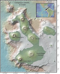
The Galápagos Islands straddle the equator at 91.5W. They are about 1000 km (600 miles) west of Ecuador and 200 km south of the Galápagos spreading center. They formed, and in the case of Isabela and Fernandina, are forming on the Nazca plate as it moves eastward over a mantle plume, or hotspot. Mantle plumes are columns of molten rock that form over a "hot spot" in the Earth’s mantle. The plume rises through the mantle because molten rock is less dense than surrounding solid rock. When a stationary, molten plume intersects a moving plate at the Earth’s crust, chains of volcanoes form. The Galápagos Islands and volcanoes are such a chain, as are the Hawaiian Islands. The close proximity of the Galápagos hotspot to an active spreading center and some distinctive differences between the Galápagos shield volcanoes and Hawaiian shield volcanoes raise interesting questions and make this tectonic setting an excellent study area. We will not be the first geologists and geophysicists to work in the Galápagos Islands. Perhaps Charles Darwin could make that claim as many of his observations had a decidedly geologic “flavor.” We will, however, be tackling and communicating the latest series of scientific questions, and using cutting edge ideas and technology to find the answers to the following critical questions.
What is actually happening in the magma reservoir below the volcanic crater? How does magma rise through the plate? What is the relationship between magma movement and earthquakes, or in other words, which comes first, the magma or the quake? By integrating seismic, geodetic and petrologic data to create a 4D model these questions can be answered. Understanding how basaltic magma rises through oceanic crust is not only interesting and exciting but also critical to predicting and planning for earthquakes and volcanic eruptions.
So, what are these critical questions? Why does it require three different geologic disciplines to answer them? Those preliminary questions beg some background information about the tectonic setting of the Galápagos Islands.
The Galápagos Islands straddle the equator at 91.5W. They are about 1000 km (600 miles) west of Ecuador and 200 km south of the Galápagos spreading center. They formed, and in the case of Isabela and Fernandina, are forming on the Nazca plate as it moves eastward over a mantle plume, or hotspot. Mantle plumes are columns of molten rock that form over a "hot spot" in the Earth’s mantle. The plume rises through the mantle because molten rock is less dense than surrounding solid rock. When a stationary, molten plume intersects a moving plate at the Earth’s crust, chains of volcanoes form. The Galápagos Islands and volcanoes are such a chain, as are the Hawaiian Islands. The close proximity of the Galápagos hotspot to an active spreading center and some distinctive differences between the Galápagos shield volcanoes and Hawaiian shield volcanoes raise interesting questions and make this tectonic setting an excellent study area. We will not be the first geologists and geophysicists to work in the Galápagos Islands. Perhaps Charles Darwin could make that claim as many of his observations had a decidedly geologic “flavor.” We will, however, be tackling and communicating the latest series of scientific questions, and using cutting edge ideas and technology to find the answers to the following critical questions.
What is actually happening in the magma reservoir below the volcanic crater? How does magma rise through the plate? What is the relationship between magma movement and earthquakes, or in other words, which comes first, the magma or the quake? By integrating seismic, geodetic and petrologic data to create a 4D model these questions can be answered. Understanding how basaltic magma rises through oceanic crust is not only interesting and exciting but also critical to predicting and planning for earthquakes and volcanic eruptions.